


Special Map Products Available for Purchase
The following maps were created for Railroad Commission use and are currently available for purchase.
Contact the Well Mapping Section at 512-463-6851 or mapping@rrc.texas.gov to place an order.
Provide the following information when placing your special map order:
- Your Name and/or Company Name:
- Mailing Address:
- Daytime Telephone Number:
- Shipping Method: U. S. Postal Service or FedEx.
If you have an account number, please provide the number and FedEx will bill you separately. - Method of Payment: check, MasterCard or Visa
- Price does not include postage.
- Map Name: Special Map Name, ex. OGM0026
- Standard well location maps based on USGS 7.5’ quadrangle map format.
Available scales, 1”=2,000’ or 1”=1,200’.
Indicate desired quad(s) by quad name or quad number.
Please do not submit any credit card information at this time. You will be contacted by phone by a representative from the Commission's Central Records section with the total cost of your order and for credit card information if applicable. After your payment is received, your order will be processed and delivered.
|
Railroad Commission of Texas |
Railroad Commission of Texas |
| No. | Title | Date | Layout | Price | Product Description |
|---|---|---|---|---|---|
|
OGM0141 |
July 2019 |
19”x19” |
$11.00 |
Active permit (blue) and Producing Gas (red) and Oil (green) well in the Eagle Ford Shale Play area. Railroad Commission districts and County boundaries. |
|
|
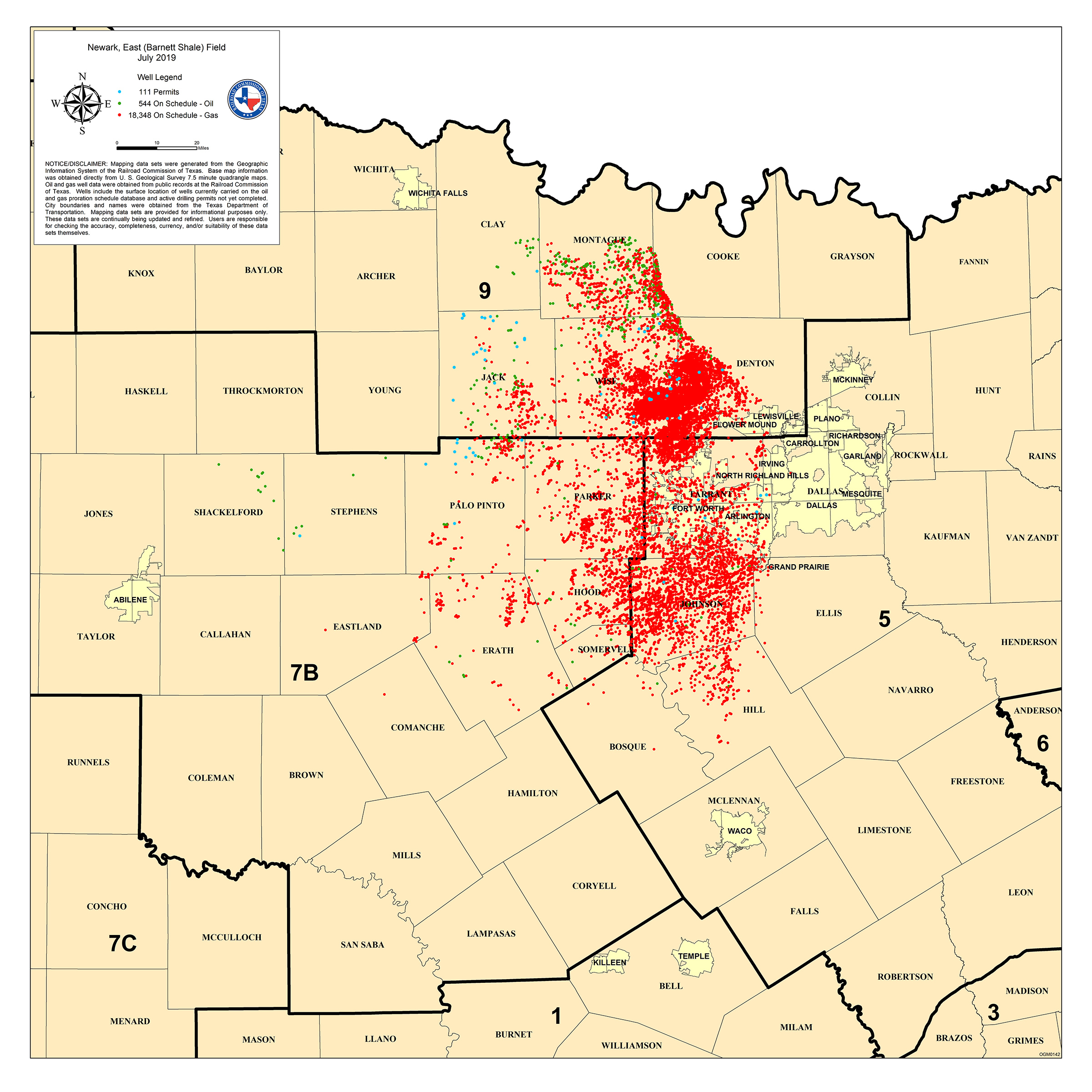
OGM0142 |
July 2019 |
19”x19” |
$11.00 |
Active permit (blue) and Producing Gas (red) and Oil (green) wells in Newark, East (Barnett Shale) field, major cities, Railroad Commission districts and county boundaries. |
|
|
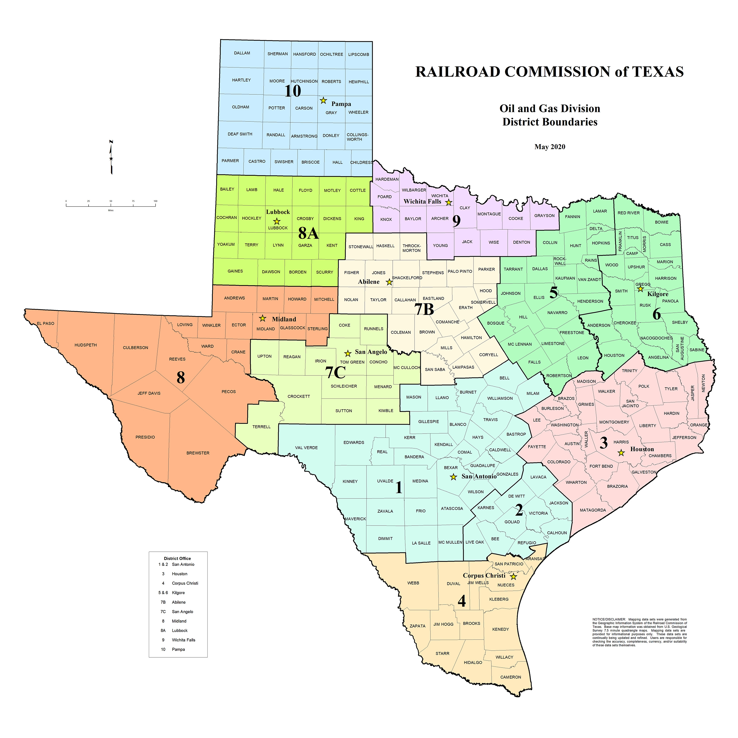
OGM0143 |
January 2018 |
36"x36" |
$23.00 |
Oil and Gas Division district boundaries, district offices, and Texas counties. Districts in various colors. Color inkjet plot. | |
|
OGM0144 |
March 2020 |
36"x36" |
$23.00 |
Top 20 producing oil and gas fields. Approximate field outlines depicted by various cross hatching symbols. Oil and gas division district boundaries and county boundaries. |
|
|
OGM0145 |
Current and Historical Producing Oil and Gas Wells and Other Permitted Well Locations |
January 2021 | 36"x36" | $23.00 |
Current and historical producing oil (green) and gas (red) wells. The other (blue) wells include new locations, dry holes, injection, disposal, service, water supply and geothermal wells. County and RRC district boundaries. |
| OGM0146 |
Wells Permitted and Completed in the Eagle Ford Shale Play  |
January 2021 | 19"x19" | $11.00 |
Active permit (blue) and Producing Gas (red) and Oil (green) well in the Eagle Ford Shale Play area. Railroad Commission districts and County boundaries. |
| OGM0147 | Newark, East (Barnett Shale) |
January 2021 | 19"x19" | $11.00 |
Active permit (blue) and Producing Gas (red) and Oil (green) wells in Newark, East (Barnett Shale) field, major cities, Railroad Commission districts and county boundaries. |
| OGM0148 | Texas Pipelines |
January 2021 | 36"x36" | $23.00 |
Natural gas pipelines (red), crude oil pipelines (green), hazardous pipelines (blue), Railroad Commission Pipeline Safety Division regions and county boundaries. Color inkjet plot. |


Mapping data sets were generated from the Geographic Information System of the Railroad Commission of Texas. Base map information was obtained from U.S. Geological Survey 7.5 minute quadrangle maps. Patent Survey lines from Texas General Land Office maps were interpreted onto the U.S. Geological Survey base. Oil and gas well data and pipeline data were obtained from public records at the Railroad Commission of Texas. Mapping data sets are provided for informational purposes only. These data sets are continually being updated and refined. Users are responsible for checking the accuracy, completeness, currency, and/or suitability of these data sets themselves. This is not a survey grade product and should not be used to define or establish survey boundaries.
Useful Links